We're proud to offer a simple, accurate, and up-to-date database of United States neighborhoods. We've built it from the ground up using authoritative sources such as local GIS departments, the U.S. Geological Survey, the U.S. Census Bureau, and original web research.


Databases | Basic | Pro | Comprehensive |
|---|---|---|---|
| Commercial use | Allowed | Allowed | Allowed |
| File format | CSV, Excel | CSV, Excel, SQL | CSV, Excel, SQL, Shapefile/JSON* |
| Neighborhoods in 25 largest cities | Yes | Yes | Yes |
| Neighborhoods in 738 cities** | No | Yes | Yes |
| Number of entries | 3,592 | 30,139 | 30,139 |
| Fields (listed below) | Basic fields | All fields | All fields |
| GIS Shapes* (.shp, .json) | No | No | Yes, for over 27 thousand neighborhoods in 286 cities |
| Future updates | Not guaranteed | Included for 12 months | Included for 24 months |
| Attribution | Required | Not required | Not required |
| License | Creative Commons Attribution 4.0 | Permissive, no redistribution | Permissive, no redistribution |
| Refund policy | N/A | 30-day guarantee | No refunds |
| One-time fee | Free | $499 | $2,999 |
| Buy Now! | Buy Now! |
*GIS shapes are provided in a single Shapefile/GeoJSON file that includes the neighborhood's id, name, and shape.
**Some cities are only partially covered.
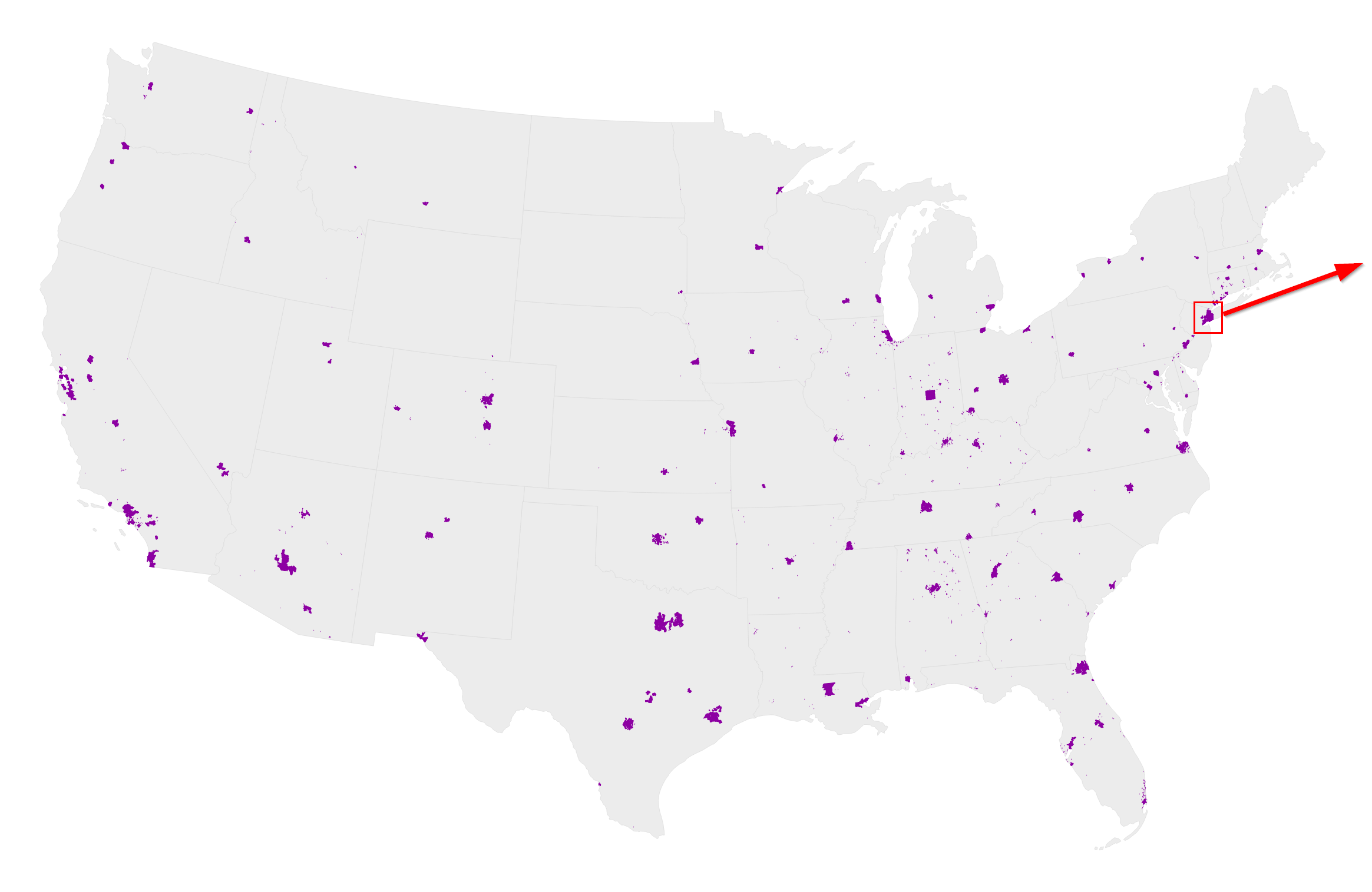
Here is a visualization of the data in the continental United States in our paid databases:
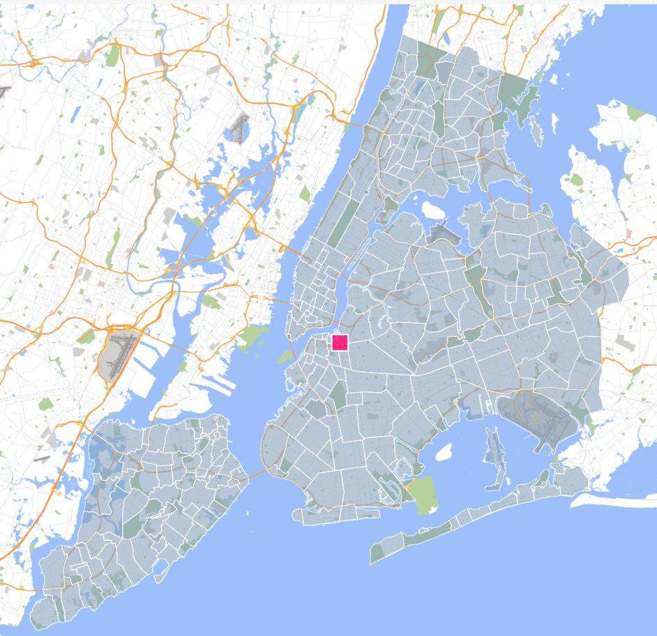
Example of neighborhood shapes (Comprehensive version only) in NYC visualized over an OSM map.
Here is a sample of rows from the database with some commonly used fields:
| fieldname | description | Basic | Pro | Comp. |
|---|---|---|---|---|
neighborhood |
The name of the neighborhood. | |||
neighborhood_ascii |
neighborhood as an ASCII string. |
|||
city_name |
The name of the neighborhood's city/town. | |||
city_id |
The id of city_name. Consistent with our US Cities Database. |
|||
lat |
The latitude of the neighborhood. | |||
lng |
The longitude of the neighborhood. | |||
state_id |
The state or territory's USPS postal abbreviation. | |||
state_name |
The name of the state or territory that contains the neighborhood. | |||
county_fips |
The 5-digit FIPS code for the primary county. The first two digits correspond to the state's FIPS code. | |||
county_name |
The name of the primary county (or equivalent) that contains the neighborhood. | |||
county_fips_all |
The 5-digit FIPS code for all counties that overlap the neighborhood (e.g. 04013|04021) | |||
county_name_all |
The name of all counties that overlap the neighborhood. (e.g. Maricopa|Pinal) | |||
timezone |
The city's time zone in the tz database format. (e.g. America/Los_Angeles) | |||
zips |
A string containing all five-digit zip codes in the neighborhood, delimited by a space. Learn more. | |||
id |
A unique id for the neighborhood generated by SimpleMaps. It is consistent across releases. | |||
source |
For some cities, our data is generated from a polygon representing the city, for others we simply have a point. | |||
cbsa_fips |
The FIPS code for the Core Based Statistical Area (CBSA) that includes the city (if one exists). | |||
cbsa_name |
The name of the CBSA (e.g. New York-Newark-Jersey City). | |||
cbsa_metro |
TRUE if cbsa_name is a metropolitan statistical area (MSA). FALSE if the CBSA is a micropolitan statistical area (μSAs). |
|||
csa_fips |
The FIPS code for the Combined Statistical Area (CSA) that includes the city (if one exists). | |||
csa_name |
The name of the CSA (e.g. New York-Newark). |
What do you consider to be a neighborhood?
A neighborhood is any named community within a city/town. Neighborhoods can overlap other neighborhoods. They can be a point or an area. They are subjective by nature, so people may disagree on neighborhood boundaries.
Do you consider subdivisions to be neighborhoods?
Sometimes. In older cities, neighborhoods tend to be well-defined, and we do not include subdivisions. In newer cities with less well-defined neighborhoods, we may include subdivisions as they act like neighborhoods.
Am I allowed to redistribute the database if I purchase a paid license?
No. You are not allowed to sell the database or make it publicly available. However, you can make copies and backups of the data. You are also allowed to query the database to power publicly facing applications, such as a store locator. To learn more, read the full license terms.
How often do you release updates?
Typically a few times a year. Upon purchase, you can elect to receive email alerts when we release new versions of the database.
Why don't you include any demographic data like age, income, population, etc.?
Typically, neighborhoods do not exist in any official capacity. Therefore, the U.S. Census does not collect demographic data on them. However, in future releases, we're hoping to create demographic estimates for our neighborhoods using Census areas that overlap the neighborhoods.
Why is this product more expensive than your other databases?
Neighborhood boundaries are not well-tracked by the federal government. So, this database has required countless hours of manual labor collecting data from local agencies, original research, and data cleaning.
Why should I trust this data?
This database was aggregated from authoritative sources and carefully processed by SimpleMaps. We've been developing and selling interactive maps to Fortune 500 companies and prominent international organizations for over 16 years. Over this time, we've learned a lot about geographic data. To get a sense of the expertise and support we offer, check out some of the testimonials from our happy customers.
If I use the free database, what type of attribution is required?
If you use the Basic (free) database, you must link back to this page:
https://simplemaps.com/data/us-neighborhoods
from a public webpage where you are using the data. If you want to use the data internally, you must link back to this page from your firm's website on a page that can be easily found through links on the root domain. The link must be clearly visible to the human eye.
How do I calculate the distance between two neighborhoods?
We've published free formulas in popular programming languages. Check them out.
How do you determine which zip codes are in a neighborhood?
Our zip code data comes from our Zip Code Database. Most zip codes are Zip Code Tabulation Areas and are represented as a geographic area. We consider a ZCTA to be part of a neighborhood if the area intersecting both the ZCTA and neighborhood is at least 10 percent of the area of either the neighborhood or the ZCTA. This means that a ZCTA can be in more than one neighborhood. If this method does not result in a zip code, we will use the closest zip in the immediate area.
I only need neighborhood shapes for a single city, can I just buy those?
Yes, we sell single city data as a map product.
Do you have any sample data so that I can see what's included?
Yes, our neighborhood maps are generated using our neighborhood data and will give you a good sense of what's included for a given city.
Home (Maps) | Database License | Privacy | Database Releases | Database Order Lookup | Resources | Contact | FAQs
SimpleMaps.com is a product of Pareto Software, LLC. © 2010-2026.